Farm Share Closing Food Gap
ALACHUA COUNTY – Local communities are feeling the impacts of COVID-19 in a number of ways beyond health and safety aspects. Due to social distancing, loss of jobs, less commerce and transportation, economies locally and throughout the world are facing a serious downfall.
This means that governments have had to spend much of their resources to help support both individual and businesses, which have been affected by various measures mandated by federal, state, and local authorities. One of the side effects of weakened economies, less commerce and inability to transport or import, is its effect on the supply chain, especially food.
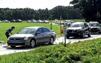
Food organizations such as Feeding America, Bread For the World and Farm Share are working to distribute as much as they can by partnering with local community volunteers and churches. On April 29 at the Easton Sports Complex in Newberry, a long line of cars slowly wound its way past a series of tables and pallets containing bags of food. Each table had been set up with different food products at each station. As the cars slowly moved down the line, volunteers would load the open trunks with bags of food. Respecting the rules on social distancing and health cautions, each volunteer wore a mask and gloves, putting the food bags in the trunks so there was no physical interaction. Between 9 a.m. and noon, over 500 cars went through the line.
While the U.S. is the wealthiest country in the world with over $105,990 billion in wealth, there is a shockingly high number of citizens that have trouble getting enough food. In 2017, 40 million people struggled with hunger in the United States and today 45 million Americans rely on stipends from the Supplemental Nutrition Assistance Program (SNAP) to buy food each month, according to the USDA. Two-thirds of these benefits go to households with children.
When schools closed due to COVID-19, it temporarily cut off the meals, but educators nationwide and the Federal government have organized programs to continue the meals.
The majority of the people on food assistance programs have jobs, but many are in low income and service industries where a single paycheck makes a difference in covering the bills and food. Now, many of these jobs are gone and the families are left with no income.
Farm Share was established in 1991 by Patricia Robbins, owner of a commercial seafood company. When she retired in 1991, she founded the Farm Share program with the goal of recovering wasted produce and supplying it to various organizations and directly to the public to help alleviate hunger caused by poverty for lower income families and the elderly.
The concept was based on the fact that up to 50 percent of the produce raised on farms is thrown away. Typically stores want to provide the best product to their customers and accept only produce that is cosmetically perfect. Misshapen or blemished produce is rejected, leaving the farmer little choice but to dispose of it or use it as fertilizer for their fields.
Robbins found a unique solution by working directly with the farmers to get this wasted food to people in need. This simple but innovative idea has now grown into an organization that feeds millions of people and distributes more than 88 million pounds of healthy and nutritious food annually. Farm Share also works with the federal government to distribute packaged goods and gets donations and funds from the general public
COVID-19 has had a huge impact on Farm Share's distribution. Most of the food distribution events have doubled in people needing assistance. Farm Share has four distribution warehouses in Florida. The Jacksonville center covers much of North Florida and is doing about eight events a week in addition to doing 1,800 drop-offs to senior living facilities.
This Saturday, May 9, they will hold two distribution events in Northeast Florida for people in need. Farm Share will be at the High Springs Civic Center from 9 a.m. -11 a.m. and at the Lake Butler Community Center from 9 a.m. -11 a.m.
For other dates and locations of events or to contact the organization to volunteer time or donate funds, go to www.farmshare.org.
# # #
Email rcarson@
alachuatoday.com
Add a comment